The blizzard that struck Southern New England on February 23, 2026, will be remembered as one of the most significant winter storms to impact the region in decades. As meteorologists began issuing warnings several days earlier, the growing consensus was that all the necessary atmospheric ingredients were in place for a major snow event. Residents who have experienced memorable storms such as the Blizzard of 1978 or the February 2013 nor’easter immediately recognized the gravity of the situation. This storm, however, carried a unique combination of meteorological patterns that not only blanketed the region in snow but also created complex challenges related to wind, flooding, and lingering recovery efforts.

Meteorological Setup and Forecasting
The formation of the February 23, 2026 blizzard was a product of multiple converging weather systems. A strong low-pressure system originating over the central United States moved eastward, intensifying as it reached the Atlantic coastline. Simultaneously, a surge of Arctic air descended from Canada, creating a sharply defined cold boundary over Southern New England. When the warm, moisture-laden air from the Atlantic encountered this frigid air mass, it created ideal conditions for heavy, sustained snowfall.
Advancements in satellite imaging and predictive weather modeling allowed forecasters to track the storm’s development with remarkable precision. By February 21, models consistently indicated a classic nor’easter pattern, featuring a rapidly deepening low that would stall off the mid-Atlantic coast. This stalling effect enhanced snowfall totals as bands of precipitation rotated over the same areas for extended periods. Some meteorologists compared the setup to notable historical storms such as the 2005 Blizzard, though with stronger wind projections and a higher likelihood of coastal flooding due to astronomical high tides.
Forecasts in the 48 hours leading up to the storm prompted the National Weather Service to issue Blizzard Warnings for Connecticut, Rhode Island, and southeastern Massachusetts. Wind gusts of 50 to 70 miles per hour were anticipated along the coast, with inland regions expecting 20 to 30 inches of snow depending on elevation and storm banding. Local emergency management agencies urged residents to prepare for extended power outages and hazardous travel conditions.
Snowfall Totals and Regional Impacts
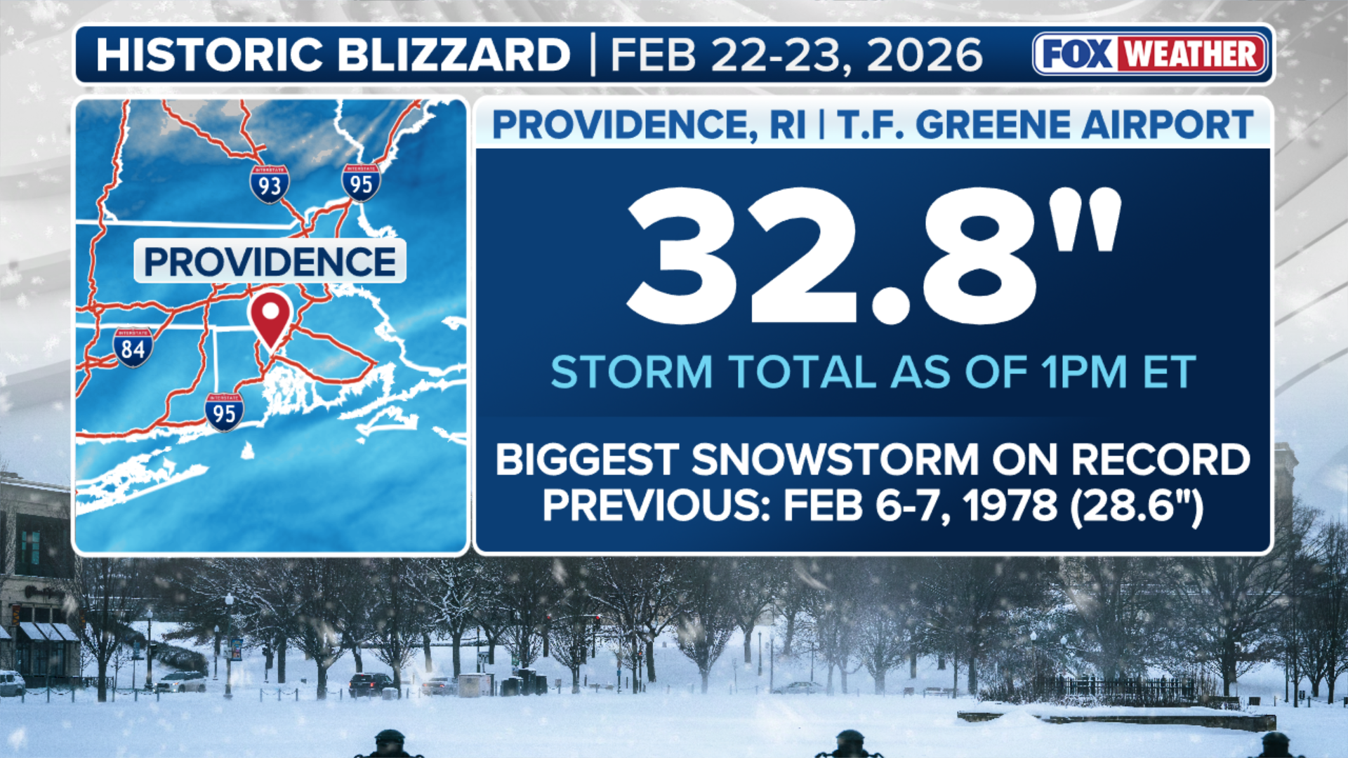
Snowfall totals varied widely across Southern New England due to the storm’s complex banding features and the influence of coastal temperatures. Coastal communities such as Newport and New Bedford initially saw a mix of heavy, wet snow and sleet, which later changed to all snow as colder air wrapped into the system. Inland towns in central Massachusetts and northern Connecticut received the highest totals, with some unofficial measurements exceeding 32 inches. Providence recorded 24 inches, marking its highest single-storm total since 2015, while Boston Logan International Airport measured 21 inches.

The blizzard’s strong winds created widespread whiteout conditions for nearly 18 hours. Numerous communities reported snow drifts exceeding six feet, which complicated snow removal efforts and temporarily trapped residents in their homes. Major highways, including I-95 and I-90, became impassable at the height of the storm, prompting local authorities to issue temporary travel bans. Public transit systems across the region suspended operations, and Amtrak canceled all service along the Northeast Corridor for the duration of the event.
The weight of the snow, combined with high winds, caused extensive tree and power line damage. By the evening of February 23, more than 750,000 customers in Southern New England were without electricity. Utility crews faced significant challenges in accessing downed lines, as secondary roads were blocked by snowdrifts and fallen branches. Restoring power to rural areas took several days, highlighting the vulnerability of the region’s infrastructure to extreme winter events.
Coastal Flooding and Wind Damage
While heavy snow dominated headlines, the blizzard’s coastal impacts were equally severe. The combination of a strong onshore wind and astronomically high tides resulted in significant flooding in low-lying areas of Rhode Island and southeastern Massachusetts. Communities such as Scituate, Plymouth, and Westerly reported inundated streets and property damage reminiscent of previous nor’easters. Seawalls faced relentless pounding from 15 to 20-foot waves, and some sections of coastal infrastructure sustained structural damage.
Wind gusts along Cape Cod and the Islands exceeded 70 miles per hour, causing localized roof damage and contributing to the widespread power outages. Emergency shelters were opened in several coastal towns to accommodate residents who evacuated from flood-prone areas. As the storm progressed, social media and local news outlets documented scenes of ice-covered homes, submerged streets, and fishing boats tossed ashore by the relentless surf.
Community Response and Emergency Management
The February 23, 2026 blizzard tested the resilience of Southern New England’s communities and emergency management systems. In the days leading up to the storm, local governments coordinated with state agencies to pre-position snow removal equipment, utility repair crews, and first responders. Many municipalities activated their emergency operations centers, ensuring continuous communication between departments and with the public.
During the storm, the emphasis was on keeping residents off the roads and providing timely updates through emergency alerts and social media. Public schools and most businesses had already closed by the morning of February 23, which mitigated the risk of motorists being stranded in whiteout conditions. Nevertheless, first responders conducted numerous rescues of individuals who underestimated the storm and attempted to travel.
Following the storm, the focus shifted to recovery and cleanup. Heavy equipment operators worked around the clock to clear main arteries, followed by residential streets. The sheer volume of snow necessitated the creation of temporary snow dumps in several cities. Local officials also had to contend with the risk of roof collapses due to the weight of the snow, particularly on older flat-roofed structures.
Long-Term Implications and Lessons Learned
Analysts and meteorologists are likely to study the February 23, 2026 blizzard for years to come, not only for its meteorological characteristics but also for its social and infrastructural impacts. The storm underscored the ongoing challenge of balancing urban development with climate resilience. While Southern New England has extensive experience with winter weather, the intensity of this event highlighted vulnerabilities in the power grid, transportation infrastructure, and emergency response systems.
In the context of climate trends, some researchers suggest that the frequency of extreme winter events may increase due to the interplay between warming oceans and shifting atmospheric patterns. Warmer ocean temperatures can provide additional moisture to winter storms, resulting in heavier precipitation when conditions are cold enough to produce snow. This blizzard, with its combination of high moisture content and Arctic air, may foreshadow future challenges for the region.
Local governments are expected to conduct after-action reviews to assess what worked and what could be improved in future storm responses. Key considerations include the timing of travel bans, the allocation of snow removal resources, and the need for enhanced coordination with utility companies to expedite power restoration in hard-hit areas.
Conclusion
The February 23, 2026 blizzard will be remembered as a defining winter event for Southern New England, combining record-breaking snowfall with punishing winds and coastal flooding. While residents will long recall the inconvenience and danger posed by the storm, it also served as a reminder of the region’s capacity for preparation, adaptation, and recovery. In the wake of the blizzard, communities pulled together to restore normalcy, demonstrating once again that New England’s resilience is as enduring as its winters.